ศูนย์ดิจิทัลชุมชน โรงเรียนราชประชานุเคราะห์ 30 · Digital Chumchon Rongrian Ratcha Pra Chanu Khro 30 Centre
ห้องน้ำใกล้สุด · Nearest toilet: โรงพยาบาลส่งเสริมสุขภาพตำบลบ้านใหม่ปู่แช่ ตำบลแม่อาย · 740 ม. ตามถนน · 740 m by road · เดิน ~9 นาที · ~9 min walk · ที่อื่นจากตรงนี้ · more from here
รอบ ๆ ที่นี่ · Around here
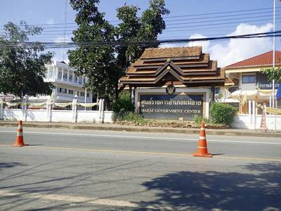
ภาพ:Photos: insiy (CC BY-SA 2.0) · ผ่าน Wikimedia Commons · via Wikimedia Commons

📰 สื่อ-ข่าว · Media & news รหัสไปรษณีย์ 50280 · 50280 postcode ต.แม่อาย · Mae Ai (subdistrict) อ.แม่อาย · Mae Ai (district)
- ศูนย์ราชการอำเภอแม่อาย · Ratcha Kan Amphoe Mae Ai Centre · 20 ม. · 20 m
- ดั่งใจ๋ - Dang jai Coffee & Bakery · 20 ม. · 20 m
- ที่ว่าการอำเภอแม่อาย · Mae Ai Government Center · 30 ม. · 30 m
- สถานีตำรวจภูธรแม่อาย จ.เชียงใหม่ · Mae Ai Cha.Chiang Mai Provincial police station · 50 ม. · 50 m
- สถานีตำรวจภูธร อ.แม่อาย · A.Mae Ai Provincial police station · 70 ม. · 70 m
- ที่อยู่ · Address
- 77 หมู่2 ตำบลแม่อาย อำเภแแม่อาย จังหวัดเชียงใหม่ 50280 Tambon Mae Ai Amphemaeai · Changwat Chiang Mai
- แผนที่ · Map
- มดแดง · Mot Dang · OpenStreetMap · Google · Apple · Geo
- รหัสที่ · Place ID
MD-JT43B- ทิศทาง · Bearings
- ห่างประตูท่าแพ 142 กม. ทางเหนือ · 142 km north of Tha Phae Gate
ย่านฝาง-แม่อาย-ไชยปราการ · Fang, Mae Ai & Chai Prakan
ชื่อ-ที่อยู่ Overture Maps · CDLA-Permissive-2.0 · Name & address Overture Maps · CDLA-Permissive-2.0 · 2026-10-20