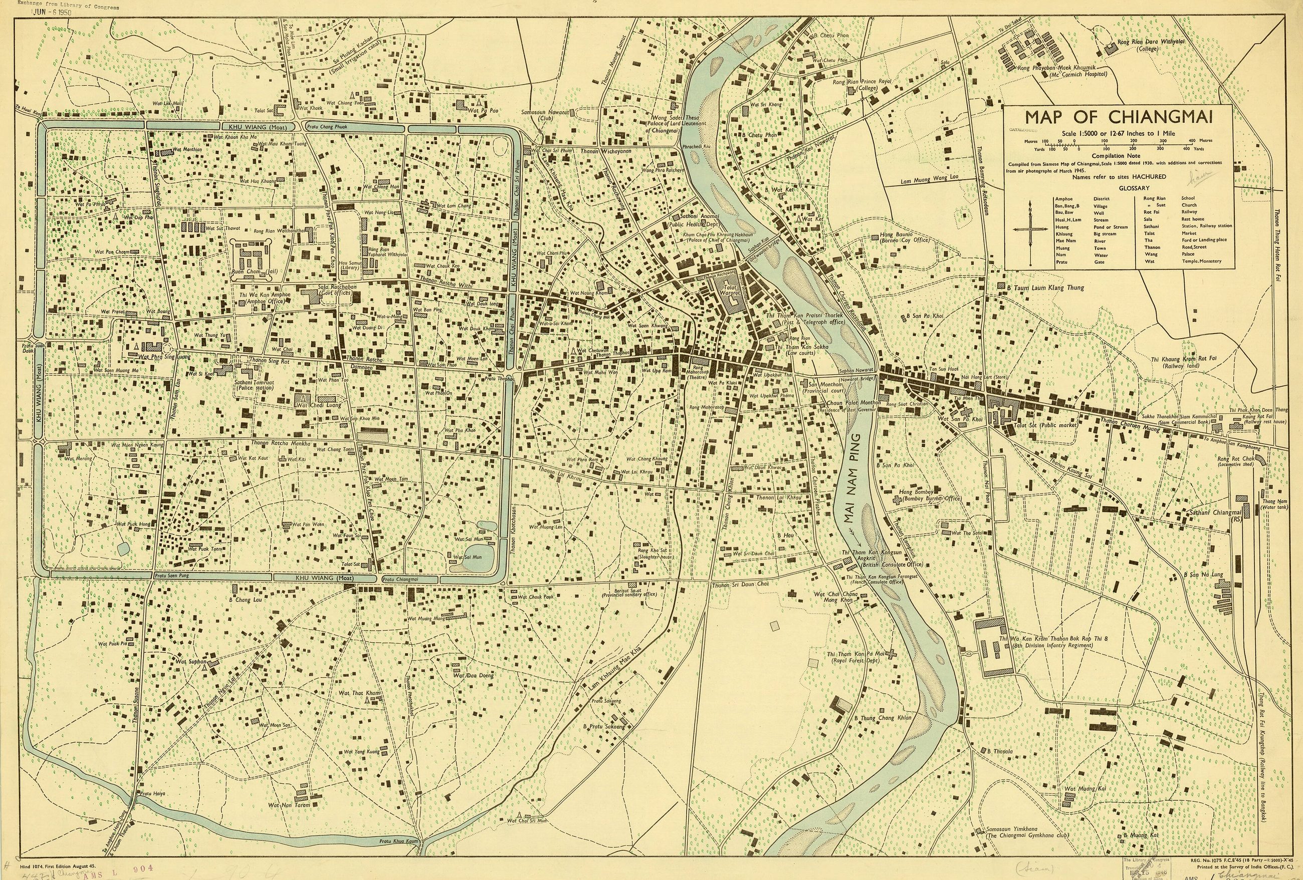
แผนที่เก่าแผนที่เมือง 2488
มาตราส่วน 1:5,000 พิมพ์ที่ Survey of India สามปีก่อนถนนรอบคู
 Survey of India Offices · Public domain
คืออะไร
พิมพ์ที่สำนักงาน Survey of India มาตราส่วน 1:5,000 ขนาด 57 คูณ 87 ซม. เก็บโดย American Geographical Society เป็นแผนที่แผ่นสุดท้ายบนเว็บนี้ที่แสดงเวียงเก่าก่อนเทศบาลสร้างถนนสองฝั่งคูในปี 2491 และรื้อกำแพงบางช่วงเพื่อทำอย่างนั้น
ฉบับยาว
อนุมาน — แผ่นนี้กับแผ่นสมัยใหม่ วางเคียงกัน คือข้อโต้แย้งทั้งหมดของเว็บนี้ในสองภาพ สี่เหลี่ยมยังเป็นสี่เหลี่ยมเดิม ทุกอย่างนอกมันต่างไป และความต่างคือวงแหวน
วิธี
อ่านจากแผ่นเอง หมายเหตุการจัดทำบอกว่าทำจากแผนที่เมืองเชียงใหม่ของสยาม มาตราส่วน 1:5,000 ลงปี 2473 พร้อมเพิ่มเติมและแก้ไขจากภาพถ่ายทางอากาศเดือนมีนาคม 2488 พิมพ์ครั้งแรกสิงหาคม 2488 ที่สำนักงาน Survey of India ชุด L904 ของ Army Map Service และฉบับนี้มีตราแลกเปลี่ยนของหอสมุดรัฐสภาอเมริกันเดือนมิถุนายน 2493 คูเมืองกำกับว่า KHU WIANG (Moat) ทั้งสี่ด้าน อภิธานของมันแปลคำที่เว็บนี้สร้างขึ้นจาก ถนนคือ Road หรือ Street ประตูคือ Gate ท่าคือที่ข้ามหรือที่ขึ้นบก ตลาดคือ Market วัดคือ Temple หรือ Monastery คลองคือบ่อหรือลำธาร
เกี่ยวข้องกับ
- ถนนรอบคูเมือง Built three years later.
- 2443–2493 — สยามกับรถไฟ Its era.
- ถนนทำอะไรกับเมืองเก่า The argument.
- คู It labels the moat with this word.
- เวียง And with this one.
- ถนน Its glossary defines it.
ถูกอ้างถึงโดย
- แผ่นของ War Office 2489 Its city-scale sibling.
- คู Labels it khu wiang.
- เวียง Where it is written.
แต่ละข้อความมาจากไหน
| Field | Tier | Source | Note |
|---|---|---|---|
| default | cited | Wikimedia Commons — the map and photograph files, each with its own licence on its file page — Wikimedia Commons | |
| text_th | inference | written in Thai by this project, in the northern register where it fits; not machine-translated | |
| text.story | inference |
แหล่งอ้างอิง
- Wikimedia Commons — the map and photograph files, each with its own licence on its file page — Wikimedia Commons
cited Cited — a named source, linked · harvested Harvested — fetched from an open dataset, with its licence · tradition Tradition — general knowledge of the tradition, hedged · inference Inference — this project's own reasoning from the above · field Field — someone stood there