mapThe 1945 city map
แผนที่เมือง 2488
1:5,000, printed at the Survey of India, three years before the moat roads.
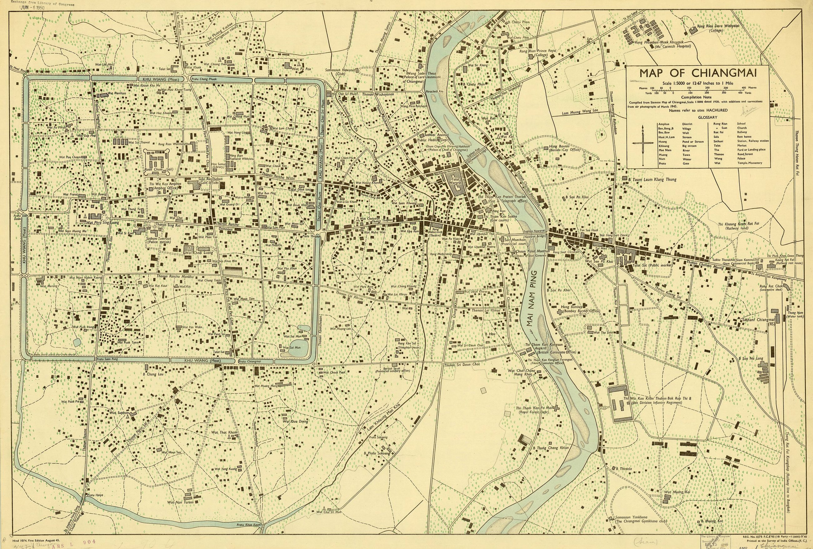 Survey of India Offices · Public domain
What it is
Printed at the Survey of India offices at 1:5,000, 57 by 87 cm, held by the American Geographical Society. It is the last map on this site that shows the old city before the municipality built the roads on both banks of the moat in 1948 and demolished stretches of the wall to do it.
The long version
Inference — this sheet and a modern one, laid side by side, are the whole argument of this site in two pictures. The square is the same square. Everything outside it is different, and the difference is rings.
How
Read off the sheet. Its compilation note says it was made from a Siamese map of Chiangmai at 1:5,000 dated 1930, with additions and corrections from air photographs of March 1945. First edition August 1945, printed at the Survey of India Offices, Army Map Service series L904, and the copy carries a Library of Congress exchange stamp of June 1950. The moat is labelled KHU WIANG (Moat) on all four sides. Its glossary translates the words this site is built on: Thanon is Road or Street, Pratu is Gate, Tha is a Ford or Landing place, Talat is Market, Wat is Temple or Monastery, Khlong is a Pond or Stream.
Connected to
- The moat loop Built three years later.
- 1900–1950 — Siam and the railway Its era.
- What a road does to an old city The argument.
- คู khu It labels the moat with this word.
- เวียง wiang And with this one.
- ถนน thanon Its glossary defines it.
Named here by
- The War Office sheet, 1946 Its city-scale sibling.
- คู khu Labels it khu wiang.
- เวียง wiang Where it is written.
Where each claim comes from
| Field | Tier | Source | Note |
|---|---|---|---|
| default | cited | Wikimedia Commons — the map and photograph files, each with its own licence on its file page — Wikimedia Commons | |
| text_th | inference | written in Thai by this project, in the northern register where it fits; not machine-translated | |
| text.story | inference |
Sources
- Wikimedia Commons — the map and photograph files, each with its own licence on its file page — Wikimedia Commons
cited Cited — a named source, linked · harvested Harvested — fetched from an open dataset, with its licence · tradition Tradition — general knowledge of the tradition, hedged · inference Inference — this project's own reasoning from the above · field Field — someone stood there